
RSS uses state-of-the-art monitoring and modelling techniques to provide valuable information on global forests. These services include Monitoring, Reporting and Verification (MRV) in the context of Forest Landscape Restoration and Reducing Emissions from Deforestation and Degradation (REDD+) activities. We also specialize in providing digital twins of forests, in monitoring forest cover change and forest biomass and carbon stock assessments.
Carbon Stock
Data-driven evidence:
- Forest carbon stock assessment
- Activity data on deforestation and forest condition
- Historic & dynamic baseline assessments
- Pre-assessments and early project development support
- Due diligence of carbon projects
Remote Inventories
Seeing the trees for the forest:
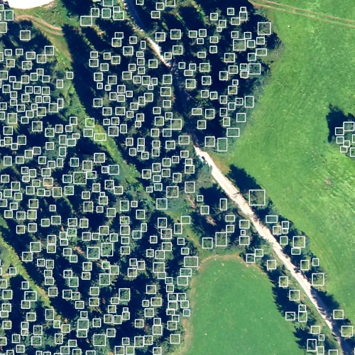
- Single tree detection using VHR data
- Canopy heights
- Tree species diversity
- Satellite & airborne data processing
- Damage Assessments
ARR/FLR Monitoring
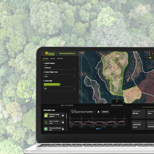
Monitor the impacts:
- Monitoring Platforms for Afforestation, Reforestation & Revegetation Projects
- VCS-conform digital MRV (dMRV)
- Data-driven key performance indicators & dashboards
- Transparent tracking of Forest Landscape Restoration (FLR)
REDD+
Forests are biodiversity hotspots, store huge amounts of carbon in their above- and below-ground biomass and provide various ecosystem services to local communities. Unfortunately, land use intensification and unsustainable forest management practices lead to significant greenhouse gas emissions.
Voluntary carbon markets have emerged alongside UN-REDD+, which offer financial incentives for reducing emissions from deforestation and forest degradation as well as sustainable forest management. RSS has participated in REDD+ readiness and voluntary carbon projects since carbon accounting began, aiding projects ranging from technical consulting, forest monitoring and MRV-methodology development to capacity development among stakeholders.
Baseline assessment
- Analysis of the historical forest conditions and their changes
- Benchmarking current forest characteristics
- Baseline carbon assessments & Due diligence
- Dynamic baseline assessments applying a performance benchmark approach
- Pre-assessments for project developers
- Longterm monitoring
MONITORING, REPORTING AND VERIFICATION
RSS uses high-resolution optical and radar satellite data synergistically, analyzing historical trends in deforestation, forest degradation, aboveground biomass and other forest parameters.
To analyze the current forest conditions, we use satellite-based solutions as well as data from drones or airborne surveys for very high-resolution insights, whereby AI methods are used to identify main tree species, canopy heights and more. RSS has been supporting REDD+ projects through technical MRV since the beginning of the voluntary carbon market. Our developed methods are also applicable in afforestation and reforestation projects, as well as in sustainable forest management. Due to many years of experience in forest monitoring across different forest ecosystems globally, RSS has gained a deep understanding of various needs of forest managers. Being actively involved in the development of standards such as VCS, national forest monitoring standards or the High Carbon Stock Approach, our products and services are specifically tailored to meet these requirements.
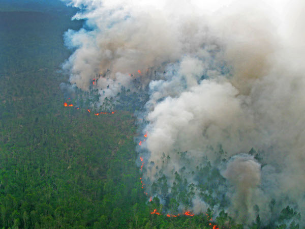
IMPACTS OF FIRE
Forest fires affect millions of hectares of forests every year through serious degradation of the forest ecosystems.
We use remote sensing to assess the impacts of the fires to the tropical forest ecosystem and on biodiversity spatially and temporally. Forest fires alter the composition of the forest vegetation by suppressing certain species and promoting other species. Often forest become more susceptible to fire, because subsequent fires burn with increased velocity and intensity and cause higher tree mortality. Forest managers can use data on fire impact and frequency to adapt forest management and for developing strategies for integrated fire management.
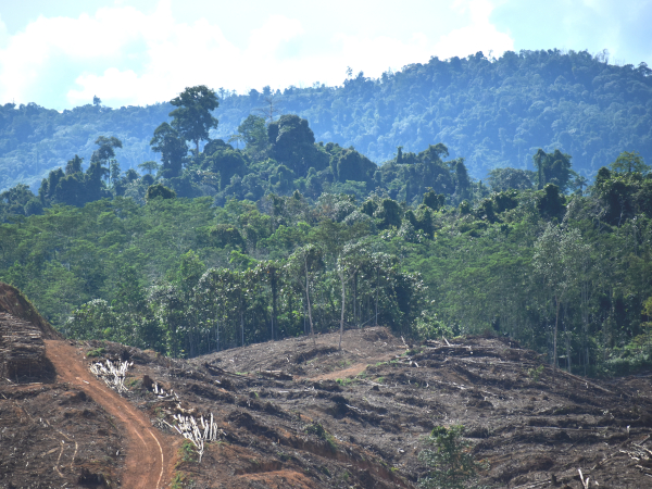
DEFORESTATION & FOREST DEGRADATION
Our monitoring approach that makes synergistic use of high-resolution optical and radar satellite data, identifies the current state of forests, the extent and density of forest cover, and its changes over time. Historical trends of deforestation and forest degradation can be derived or a continuous monitoring can be realized. Our proprietary AI algorithm detects not only deforestation in satellite images, but also identifies forest degradation. The resulting activity data can be used for monitoring REDD+ and carbon projects, for derisking forest investments as well as for conservation and restoration activities.
